Golf Course Management System

FCSI has developed a golf course management system (GCMS) built using GIS technology. It is designed to reduce course maintenance costs and assist in the tracking and planning of course maintenance expenses. You can also automatically prepare regulatory reports (water usage, pesticide usage, etc.) which can be time consuming. How many times do you hear from the club management: "Where does the maintenance costs go towards?" This tool will allow you to better communicate where the money is being spent and what will happen when the budget is reduced.
What is GIS?
Geographic Information Systems (GIS) are being used for asset management and maintenance in the utility industries and municipalities. GIS has proven to dramatically reduce maintenance costs and regulatory expenses. In addition to real savings, estimates and planning are much more reliable using GIS information and calculations. This is especially crucial in today's tough economic situation where reserves may need to be stretched over longer time periods.
Key Features
Asset Management
FCSI's GCMS stores all your data into a GIS database which identifies the locations of assets such as irrigation, utilities, buildings, and equipment. The course layout is also stored so you have a very accurate digital model of your course that can be used to reduce waste by precisely ordering supplies like fertilizer and pesticides.
Work Flow Management
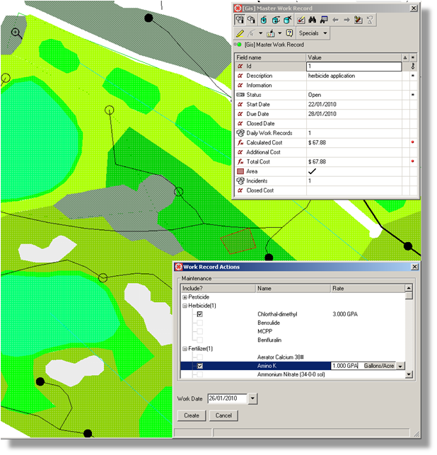
GCMS allows you ability to create incident reports and work orders. From this recorded data, you can track maintenance costs as well as identify recurring problem areas. The automatic estimate of the work costs are based on the resolution plan and geographic area of the incident. You can also create recurring activities that will provide you with a working budget you can use to propose to the club management.
Reporting
GCMS gives you the ability to record water usage and chemical application data is recorded during work order generation. This recorded data can be used to compile reports for your local water district management and environmental protection authorities. GCMS is provided with several basic report generators that can be modified to support your specific needs.
Network and Geometrical Analysis
The underlying GIS technology gives you the ability to trace potential common points of failure in the irrigation or drainage network. For example: if you have 3 sprinklers malfunctioning you can trace what is common between the three sprinklers and identify a valve, a fitting, or wiring that may be the root cause of the problem. This will save you money by identifying the most probable problem ahead of time.
You can also do spatial queries to help identify underlying cause of recurring incidents. For example there could be a potential broken water pipe located at a place that seems to get repeated fungus than other locations. So instead of just applying fungicide, you can test and fix the broken pipe. This will reduce the costs of having to apply fungicide repeatedly and the best benefit is that your course remains in tournament condition!
Inventory Tracking
GCMS tracks the amount of supplies that are used for each work order. When the work is completed the calculated amount is reduced from the inventory data. This gives you information about when to order supplies. A notice will be given when a work order is created and there is not enough supplies on hand to complete the job.
Integration
FCSI can optionally provide functionality to integrate the golf course management software with external systems. below is some examples.
- Irrigation systems can be controlled so water usage is based on rainfall, weather, soil type, and elevation information
- Use GPS enabled devices to quickly identify incidents and update data.
- We can integrate or export cost data to support data required by back office golf club management systems.
- We can integrate the inventory and work order data with purchasing and ordering systems used by your club.